Indies Gallery
Antique Maps & Prints of Indonesia
Search
MY ACCOUNT
Sign in
Login
Create Account
Forgot Password
0
Menu
Sign in
Login
Create Account
Forgot Password
Antique Maps Indonesia
New Additions
About Us
Contact Us
Gifts Under $350
Sell To Us
Catalogues
Newsletters
Search
Asia Maps (71)
- South East Asia Maps (103)
- - India & Sri Lanka Maps (25)
- - Philippine Maps (16)
- - Thailand Maps (4)
- Indonesia Maps (131)
- - Batavia & Jakarta Maps (21)
- - Java Maps (38)
- - Sumatra Maps (35)
- - Bali & Lombok Maps (12)
- - Borneo & Kalimantan Maps (18)
- - Moluccas & Spice Islands Maps (34)
- - Papua Maps (11)
- - Sulawesi & Celebes Maps (2)
- - Flores & Komodo Maps (5)
- Singapore & Malaysia Maps (57)
- China Maps (44)
- Japan Maps (14)
- Korea Maps (20)
World Maps (15)
Australia & Oceania Maps (16)
- Australia Maps (57)
- New Zealand Maps (6)
- Oceania Maps (6)
- South Pacific Islands (4)
- Captain Cooks Voyages (3)
Americas Maps (10)
- North America Maps (6)
- Central America & Caribbean (6)
- South America Maps (7)
Europe Maps (13)
Africa Maps (10)
Pre-1750 Maps (75)
Sea Charts & Maritime Maps (22)
Arabia Maps (7)
Indonesia Prints (401)
- Inhabitants Prints (243)
- Naval & Maritime Prints (79)
- Architectural Prints (133)
- Temples in Indonesia Prints (100)
- The Old Batavia Prints (79)
- Bogor - Buitenzorg (30)
- Java Prints (340)
- Bali Prints (36)
- Sumatra Prints (34)
- Borneo Prints (60)
- Moluccas & Spice Islands Prints (111)
- Celebes/Sulawesi (10)
- Wayang Prints (41)
- Papua Prints (55)
- Dance & Music (65)
- Yogyakarta Prints (77)
- Batik Prints (86)
- Costumes & Attire Prints (128)
Malaysia & Malacca Prints (20)
Singapore Prints (42)
Views & Landscapes Prints (126)
Flora & Fauna Prints (477)
- Botanical (324)
- - Plants & Trees Prints (181)
- - Leaves Prints (209)
- - Fruits Prints (61)
- - Flowers Prints (146)
- - Spices Prints (40)
- Birds (199)
- Insects (18)
- Sea Life (104)
- Mammal Prints (47)
Mammals Prints (15)
Australia Prints (45)
- Captain Cooks Voyages Prints (51)
Ethnology Prints (110)
Exploration Prints (124)
Tribal Art Prints (57)
Oceania Prints (61)
China Prints (14)
Indian Prints (35)
Philippines Prints (9)
New Zealand Prints (3)
Antique Books (34)
Vintage Posters (17)
Singapore Photographs (63)
Indonesia Photographs (17)
- People Photographs (10)
- Batavia Photographs (6)
- Surabaya Photographs (1)
- Java Photographs (8)
- Sumatra Photographs (4)
Malaysia Photographs (2)
Architecture Photographs (32)
Streets Photographs (5)
Views & Landscapes Photographs (21)
Australia and New Zealand (5)
Tribal & Ethnographic Art (2)
Special Collection (80)
All Categories
>
Antique Maps
(347)
Antique Prints
(1428)
Antique Books
(34)
Vintage Posters
(17)
Antique Photographs
(182)
Tribal & Ethnographic Art
(2)
Special Collection
(80)
New Additions
Gifts Under $350
Catalogues
Newsletters
About Us
Contact Us
Sell To Us
Sort By :
Lowest Price
Highest Price
Recenty Added
Sold
Unsold
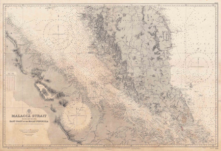
Mapmaker: British Admiralty Hydrographic Office
Singapore and the Malay Peninsula British Admiralty Nautical Chart
British Admiralty Hydrographic Office
Antique Maps
/
Singapore & Malaysia Maps
/
Sea Charts & Maritime Maps
Size
103 by 70 cm.
Condition
VG
SKU
M.0411
USD 1,400
Add to Basket
View Detail
Add to Favorites
02/08/2021